| GGIS typically refers to Geographic Graphic Information System. GGIS is an older term describing a concept that's now well-integrated into modern GIS and web mapping systems. Google Maps is a prime example of how geographic information can be visually presented and interacted with on a global scale, but it doesn't represent the full spectrum of capabilities you'd find in a dedicated GIS software package. What is GGIS?It's a somewhat archaic term for a system that combines graphical and geographical data. Think of it as the predecessor to modern GIS systems that emphasize visual representation (maps, charts, images) *along with* the underlying geographic data (coordinates, attributes of features). The key here is the *graphic* component used for visualising geographic information. Is there any Familiar GGIS to us?While the term "GGIS" itself isn't widely used today, many systems and applications you're familiar with incorporate its principles: - Modern GIS Software (e.g., ArcGIS, QGIS): These are the descendants of early GGIS systems. They excel at displaying maps (the graphical part) and allow you to analyze, edit, and manage geographic data (the information part).
- CAD Software (e.g., AutoCAD): When CAD software is used to create maps or manage infrastructure data that has geographic coordinates, it is functioning like a GGIS.
- Web Mapping Applications (e.g., Google Maps, OpenStreetMap): While they might not be as powerful in terms of complex spatial analysis as dedicated GIS software, they present geographic information visually and allow you to interact with it.
GGIS versus Google Maps- Google Maps as a User Interface: Google Maps can be seen as a highly accessible, user-friendly *output* or *visualization* tool for a broader GIS infrastructure. Google has a massive backend GIS and data infrastructure to collect, process, and store geographic data, which is then displayed in Google Maps.
- Limited GIS Functionality: Google Maps is primarily focused on navigation, search, and location information. It doesn't offer the sophisticated spatial analysis, data editing, or custom mapping capabilities of a dedicated GIS software package (ArcGIS or QGIS). You can't typically load your own custom shapefiles or run complex spatial queries directly within Google Maps (though there are some limited APIs for developers).
- Google Earth: Google Earth is more advanced than Google Maps in some GIS capabilities, and is thus more similar to the functionality of GGIS.
Who uses GGIS?- Government: Urban planning, resource management, environmental monitoring, public safety, transportation planning, census data analysis.
- Business: Market analysis, site selection, logistics and distribution, customer relationship management, real estate analysis, agriculture.
- Environment: Conservation planning, climate change research, pollution monitoring, natural disaster assessment.
- Public Safety: Crime analysis, emergency response, disaster management, fire planning.
- Healthcare: Disease tracking, health service planning, epidemiology.
- Education: Research, teaching geography and related subjects.
- Utilities: Management of infrastructure networks (e.g., water, electricity, gas).
- Transportation: Route optimization, traffic management, navigation systems.
- Telecommunications: Network planning and optimization.
- Real Estate: Property assessment, market analysis.
- Retail: Site selection, market analysis, logistics.
- Agriculture: Precision farming, crop monitoring, resource management.
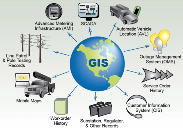
Relationship between Software Engineering and GGISWhile a Software Engineer might not *directly* be a GIS analyst or cartographer, their skills are often crucial for building and maintaining GIS software, applications, and infrastructure. Here's a breakdown of how Software Engineering relates to GIS: - GIS Software Development: Software Engineers are vital for developing the core GIS software packages (like ArcGIS, QGIS, etc.). This involves coding the user interfaces, spatial analysis algorithms, data management tools, and other essential functionalities.
- Web Mapping Applications: Building web applications that display and interact with geographic data relies heavily on Software Engineering. This includes using web frameworks (e.g., React, Angular, Vue.js) to create interactive maps, integrating with GIS servers (like GeoServer), and optimizing performance for handling large datasets.
- Mobile GIS Applications: Developing mobile apps for collecting, displaying, and analyzing spatial data in the field requires Software Engineering expertise, especially in mobile development platforms (e.g., iOS, Android).
- Spatial Databases: Software Engineers are involved in designing, implementing, and managing spatial databases (e.g., PostGIS, Oracle Spatial). This includes optimizing database performance for spatial queries, ensuring data integrity, and developing APIs for accessing spatial data.
- Geospatial Data Science and Analytics: Applying machine learning and data mining techniques to geographic data requires both GIS knowledge and Software Engineering skills to process large datasets, build predictive models, and develop visualizations.
- Cloud GIS: Developing and deploying GIS applications on cloud platforms (e.g., AWS, Azure, Google Cloud) requires Software Engineering skills related to cloud computing, DevOps, and scalability.
- Custom GIS Solutions: Many organizations need custom GIS solutions tailored to their specific needs. Software Engineers are hired to build these custom applications, often integrating with existing enterprise systems.
- GIS API Development: Creating APIs (Application Programming Interfaces) that allow other applications to access and interact with GIS data and functionality is a key role for Software Engineers.
GIS plays a significant role in various marketing strategies and operations.- Market Analysis and Segmentation: GIS can be used to analyze demographic, economic, and behavioral data linked to geographic locations. This helps marketers identify and segment target markets based on location-specific characteristics.
- Site Selection: For businesses with physical locations, GIS helps in selecting optimal sites for new stores, offices, or branches. Factors like population density, competitor locations, accessibility, and proximity to target customers are analyzed geographically.
- Targeted Advertising: GIS enables marketers to deliver highly targeted advertising campaigns by focusing on specific geographic areas with high concentrations of potential customers. This includes direct mail, digital ads, and outdoor advertising.
- Sales Territory Management: GIS can be used to define and manage sales territories, ensuring balanced workload distribution and efficient coverage of the market.
- Delivery and Logistics Optimization: For businesses involved in delivery or logistics, GIS helps optimize routes, reduce transportation costs, and improve delivery times by analyzing geographic factors like road networks, traffic patterns, and delivery locations.
- Customer Profiling: By analyzing customer data in conjunction with geographic data, marketers can create detailed customer profiles that reveal location-based preferences, behaviors, and needs.
- Competitive Analysis: GIS can map the locations of competitors, analyze their market share in different areas, and identify opportunities to gain a competitive advantage.
- Retail Planning and Management: GIS aids in understanding consumer behavior in retail environments, optimizing store layouts, and planning inventory based on location-specific demand.
- Mobile Marketing: GIS can be used to deliver location-based marketing messages to mobile devices, such as promotions when a customer is near a store or event.
- Understanding Market Penetration: GIS can map sales data to show areas where a product or service is performing well and areas where there is room for improvement.
Strategic Solutions Combining GIS and AdvertisementCombining Geographic Information Systems (GIS) and Advertising offers powerful ways to target audiences, personalize messaging, and optimize ad campaigns based on location-specific data. Here are some strategic solutions: 1. Hyperlocal Targeting & Geo-fencing: - Strategy: Define specific geographic areas (geofences) around businesses, events, or competitor locations. Serve ads only to users within these areas.
- GIS Integration: GIS helps define the geofences based on precise boundaries, demographic data, traffic patterns, or proximity to relevant points of interest.
- Advertising Examples:
- A coffee shop offering a discount to people near a competing coffee shop during their lunch rush.
- A car dealership targeting people leaving a competitor's showroom.
- A local restaurant advertising a pre-theater menu to people near a theater before showtime.
- Benefits: Increased relevance, higher click-through rates (CTRs), and improved conversion rates by reaching the most likely customers.
2. Demographic & Lifestyle Profiling: - Strategy: Identify areas with high concentrations of target demographics (age, income, education, family size) or lifestyles (urban dwellers, outdoor enthusiasts, pet owners).
- GIS Integration: GIS integrates census data, consumer behavior data, and market research data to create detailed demographic and lifestyle profiles for different geographic areas.
- Advertising Examples:
- A retirement community advertising in neighborhoods with a high percentage of senior citizens.
- A luxury car brand targeting affluent zip codes.
- A sporting goods store advertising in areas with high participation in outdoor activities.
- Benefits: Improved ad targeting, reduced wasted ad spend, and more effective messaging that resonates with the target audience.
3. Location-Based Personalization: - Strategy: Tailor ad content based on the user's location and context.
- GIS Integration: GIS provides real-time location data to understand the user's current environment (e.g., weather, time of day, proximity to specific locations).
- Advertising Examples:
- A restaurant chain showing ads for hot soup on a cold day in a particular city.
- A hotel advertising nearby attractions based on the user's current location.
- A retailer displaying local store hours and directions in their ads.
- Benefits: Enhanced ad relevance, increased engagement, and improved customer experience.
4. Proximity Marketing & "Drive-to-Store" Campaigns: - Strategy: Encourage customers to visit physical stores by offering location-based deals and promotions.
- GIS Integration: GIS helps identify potential customers within a specific radius of the store and track the effectiveness of "drive-to-store" campaigns. It can also optimize store placement and marketing efforts based on catchment area analysis.
- Advertising Examples:
- A retailer sending a push notification with a coupon to customers who are near their store.
- A gas station advertising lower prices at their location compared to nearby competitors.
- "Find the nearest store" functionality integrated into online ads.
- Benefits: Increased foot traffic, improved sales, and enhanced brand awareness in local markets.
5. Competitor Analysis & Market Optimization: - Strategy: Analyze competitor locations, market share, and customer demographics to identify opportunities for growth and competitive advantage.
- GIS Integration: GIS maps competitor locations, analyzes their catchment areas, and overlays this data with demographic and market data.
- Advertising Examples:
- Identifying underserved areas where a new business can be successful.
- Developing targeted ad campaigns to steal market share from competitors in specific locations.
- Optimizing advertising spend based on competitor activity and market conditions.
- Benefits: Improved market intelligence, better strategic decision-making, and increased ROI on advertising investments.
6. Route Optimization for Mobile Advertising: - Strategy: Display relevant ads to users based on their travel route, mode of transportation, and estimated time of arrival.
- GIS Integration: Uses GIS routing capabilities to identify the likely paths users will take and deliver timely and relevant advertisements.
- Advertising Examples:
- Displaying restaurants and gas stations along a traveler's route.
- Advertising local events happening near a bus route.
- Promoting services useful for a specific type of transportation (e.g., car repair shops for drivers, bike rentals for cyclists).
- Benefits: Increased ad relevance, higher engagement during travel time, and potential for immediate sales or brand awareness.
7. Real-Time Event Targeting: - Strategy: Leverage location data and social media to target people attending specific events in real-time.
- GIS Integration: Utilizes real-time location data, often from social media check-ins, combined with event venue location to target ads to attendees.
- Advertising Examples:
- Restaurants offering deals to concertgoers leaving a venue.
- Ride-sharing services advertising to people leaving a sporting event.
- Local retailers promoting relevant merchandise to people attending a festival.
- Benefits: Extremely targeted reach, potential for immediate conversions, and timely promotional opportunities.
Key Considerations for Success: - Data Quality: Ensure the accuracy and reliability of the GIS data used for targeting.
- Privacy Concerns: Be transparent about data collection and usage, and comply with privacy regulations.
- Mobile Optimization: Design ads that are optimized for mobile devices.
- A/B Testing: Continuously test and optimize ad campaigns based on location-specific performance metrics.
- Integration: Seamlessly integrate GIS data with advertising platforms for efficient targeting and reporting.
By strategically combining GIS and advertising, businesses can create more relevant, engaging, and effective campaigns that drive sales, increase brand awareness, and build customer loyalty. The key is to leverage the power of location intelligence to understand the target audience and deliver the right message at the right time and in the right place.
|