GGIS: The Roots of Visualizing Geographic Informationcreated at Sep 27, 2025 685 685 GGIS typically refers to Geographic Graphic Information System.GGIS is an older term describing a concept that's now well-integrated into modern GIS and web mapping systems.Google Maps is a prime example of how geographic information can be visually presen... |
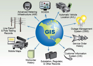
The Evolution and Applications of Geographic Information Systems: From Thematic Mapping to Efficient Data Analysis and Managementcreated at Oct 09, 2024 6,971 Geographic Information System is an information system that converts geographic information necessary for human life into computer data and utilizes it efficiently.The information system is a system that can collect, |

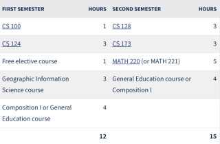
Sample Curriculum Comparison CS versus CS+GGIS at UIUCcreated at May 31, 2025 7,222 The major difference between Computer Science (CS) and Computer Science + Geography & Geographic Information Science (CS+GGIS) at UIUC lies in breadth and specialization:Computer Science (CS): The CS program is a broader, |
Understanding the Key Differences Between GIS and LBS: Purpose, created at Oct 09, 2024 |
Mastering Excel Data Manipulation with Pythonupdated at Apr 26, 2024 6,797 Python provides an awesme feature can access Excel spreadsheet file that based on pandas.You can use the pandas library in Python to read an Excel file and store its data into a Python array. Here's a basic example:Replace 'your_excel_file.xlsx' with the p... |